National Parks of Canada
The wilderness is one of Canada’s great treasures, and the Canadian National Parks are the system through which the Canadian government protects, preserves, and displays some of the country’s most impressive territory for the benefit of residents, visitors, and the environment.
What is a National Park?
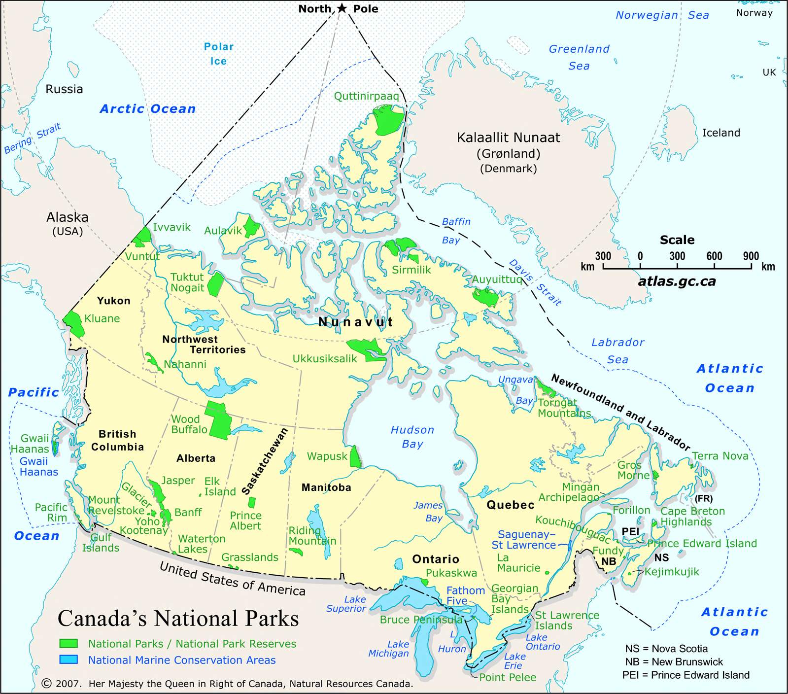
In the late 19th century, as Canada’s population continued to grow and more and more of the country’s land was used for cities, factories, mines and railroads, a land preservation movement emerged arguing the government had an obligation to protect some parts of the country from human development and destruction. Beginning in 1885, these legally-protected areas of land became known as Canada’s national parks. Today, Canada has 46 national parks which are managed by the Canadian federal government (specifically, a government agency called Parks Canada) and governed by the terms of the Canada National Parks Act.
A national park is not a “park” in the sense ordinary people use the term. Though many are interesting and fun places to visit, complete with camping grounds, hiking trails, picnic tables, beaches, and playgrounds, they also tend to be extremely large areas of land located in generally remote parts of the country, far from cities and towns. The primary purpose of a national park is to preserve land that is important, remarkable, or threatened in some way — not necessarily to make it fun or easy for humans to use. Some of Canada’s national parks, particularly those in the far north are not really intended to be visited by humans at all.
Note that every province has numerous provincial parks as well. The province of Quebec, confusingly, calls its provincial parks “national parks,” too.
What are Canadian National Parks like?
Every national park in Canada is a little bit different, but the majority are heavily forested areas with mountainous landscapes that get very snowy in the winter. Almost all have ample rivers and lakes, and about half border one of the oceans or Great Lakes. Almost all national parks can be used for hiking, cycling, kayaking, and camping, as well as skiing (though usually backcountry skiing, which does not use designated slopes or lifts) and snowshoeing during snowy months.
All of Canada’s national parks are run by the Canadian federal government and many have unique rules that must be obeyed. In theory, any park can be visited, but some require visitors to get government permission beforehand, which can vary in intensity based on the park. Many national parks do not permit camping outside of non-designated campsite areas, or require campers to request permission to camp. While the majority of national parks have government facilities within them, such as visitor orientation centres, or ranger stations to provide emergency help or assistance to visitors, many do not, meaning visitors may be taking a serious personal risk when exploring. Canada is famous for its wild animals, particularly bears, which tend to be plentiful in national parks.
National park entrance fees have been suspended for the year 2017, as part of Canada’s sesquicentennial but will resume in January of 2018.
List of Canada’s National Parks
What follows is a list of Canada’s 46 national parks, in alphabetical order. Includes Canada’s national park reserves, which, although slightly legally different, are generally considered part of the same category.
Akami-Uapishkᵁ-KakKasuak-Mealy Mountains
The largest national park in eastern Canada. A 10,700 km² northern portion of Labrador bordering the Labrador Sea and Lake Melville. Dominated by the Mealy Mountain range, it's entirely untouched wilderness with no manmade facilities.
Aulavik
12,200 km² northern portion of the Northwest Territories' northwestern Banks Island. A treeless, barren tundra, it consists entirely of untouched wilderness with no park facilities. It can only be reached by plane and receives almost no visitors.
Auyuittuq
19,089 km² northeastern portion of Nunavut's Baffin Island. Mostly occupied by the Penny Ice Cap, mountains, and glaciers. A major tourist destination for visitors to Nunavut, it offers challenging backcountry skiing, hiking, and mountain climbing. Can only be reached by plane or boat.
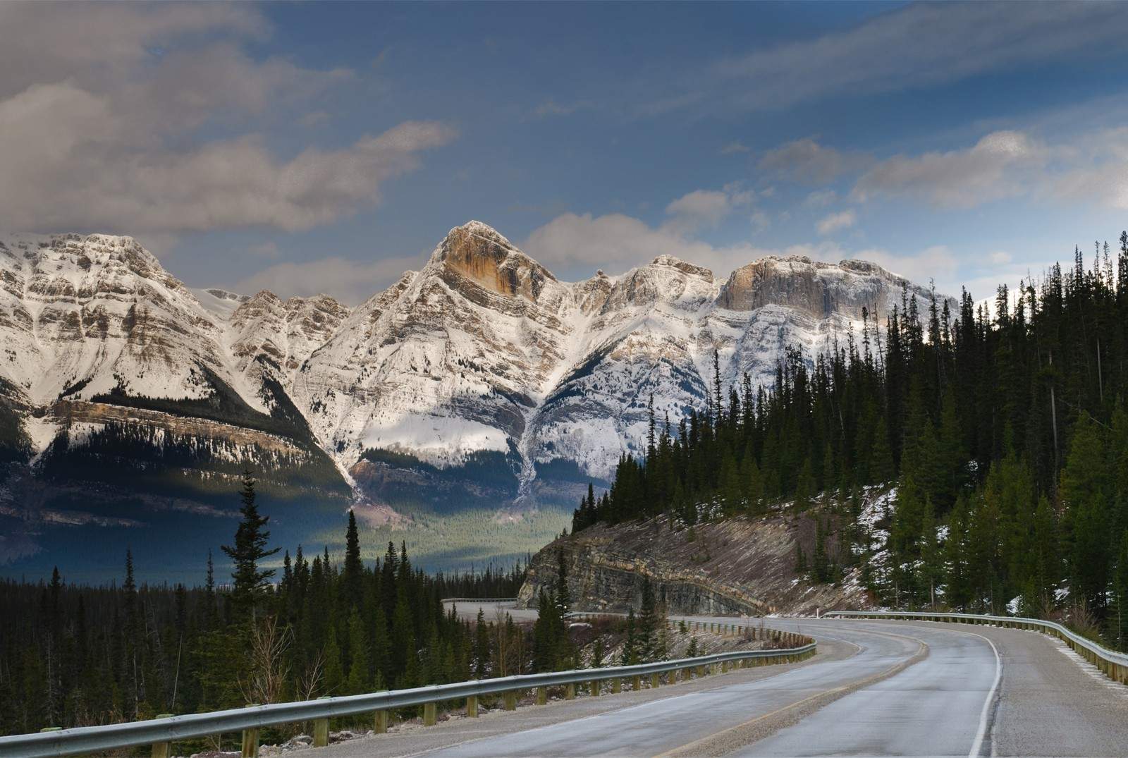
Banff
Canada's most famous national park, and one of the country's biggest tourist attractions. 6,641 km² portion of the Rocky Mountains region in western Alberta, along the border with British Columbia. Known for its large photogenic lakes, especially Lake Louise, which are popular for kayaking, as well as ski slopes, hot springs, and scenic parkways. Banff has become an extremely developed resort town, featuring plenty of modern shops, restaurants, and hotels.
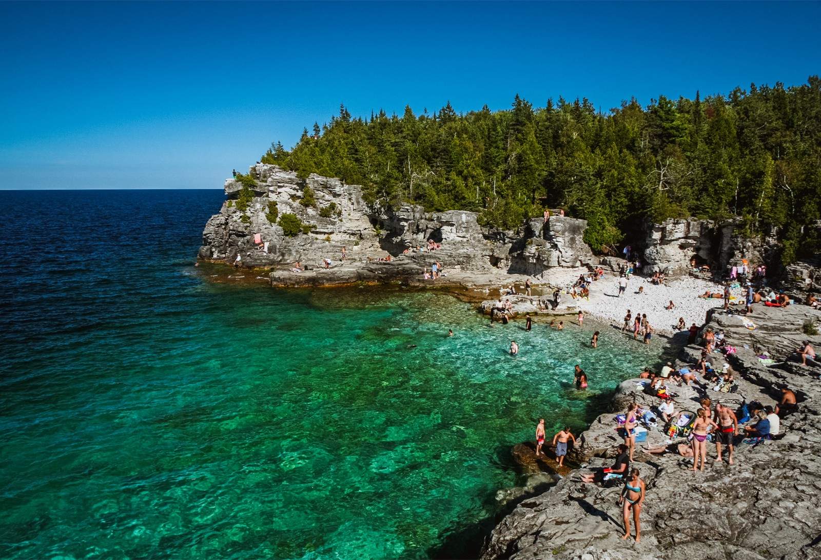
Bruce Peninsula
Small 125 km² peninsula extending from southern Ontario into the Georgian Bay of Lake Huron. Known for its rocky cliffs and clear waters. One end of the Bruce Trail, Canada's longest hiking trail, begins in this park.
Cape Breton Highlands
948 km² northern portion of Nova Scotia's Cape Breton Island. A forested plateau home to the scenic Cabot Trail highway. The area was historically important to Canada and today is a popular tourist attraction featuring museums, a golf course, and festivals in the fall.
Elk Island
Not actually an island, but a small 194 km² area of forested marsh in central Alberta. Completely surrounded by fencing, it was designed as a wildlife preserve for buffalo and elk. Popular for animal-watching, as well as picnicking and boating in Astotin Lake. Home to the Elk Island golf course.
Forillon
A 240 km² portion of land on the tip of Quebec's Gaspe Peninsula. A popular hiking destination, and features the northernmost portion of the continental Appalachian trial. Home to the Grande Grave heritage site, featuring remnants of old 18th century buildings used by early French-Canadian settlers.
Fundy
Small 206 km² portion of land in eastern New Brunswick bordering the Bay of Fundy. One of Canada's most iconic tourist sites, its craggy shore is home to the distinctive Hopewell Rocks, forged by the Bay's extremely high tides. Features a wide variety of amenities including a golf course, swimming pool, and suspension bridge. In the summer, it's used for festivals and concerts.
Georgian Bay Islands
Canada's smallest national park, consists of most of Ontario's Beausoleil Island and small portions of some other surrounding islands, located on the coast of the Lake Huron's Georgian Bay totaling only 12 km² in all. Mostly popular for kayaking, motor boating, and fishing.
Bruce Peninsula National Park, Ontario.
Nathan Bai/Shutterstock
Glacier
Not to be confused with the American Glacier National Park, Canada's Glacier is a 1,349 km² area in the Rocky Mountains region of eastern British Columbia. Known for the scenic Rogers Pass parkway, a masterpiece of early Canadian engineering, and the labyrinthian Nakimu limestone caves.
Grasslands
Two non-contiguous portions of non-agricultural land in south Saskatchewan along the U.S. border, totaling 730 km² in all. The territory is flat, dry, and desert-like, complete with rattlesnakes and cacti. Popular for horseback riding and stargazing.
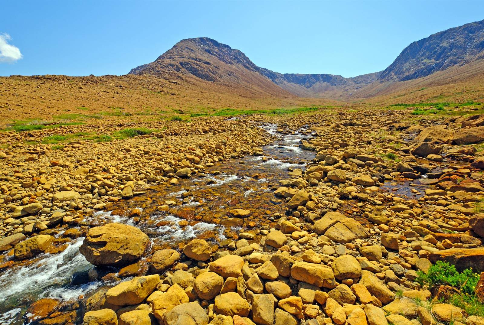
Gros Morne
1,805 km² coastal region of western Newfoundland bordering the Gulf of St. Lawerence. Rocky cliffs, large beaches, numerous ponds, and famous hiking trails provide a vast array of opportunities for activities.
Gulf Islands
Portions of scattered territory on archipelago around the southwestern corner of Vancouver Island, 37 km² in all. A variety of beaches and cliffs as well as Pacific rainforests and lagoons. A popular site for spotting whales, seals, and exotic birds.
Gwaii Hannas
Southern tip of British Columbia's Haida Gwaii archipelago off the province's northern coast. 1,474 km² of lush, coastal rainforest home to some of Canada's most exotic flora and fauna as well as vast archeological remnants of the ancient Haida civilization. Though a popular tourist destination, its distant location and highly erratic weather make it a complicated place to visit.
Ivvavik
Northernmost tip of Yukon, on the coast of the Beaufort Sea. Most of the park's 9,750 km² territory is occupied by the British Mountains range, while the rest is flat, treeless tundra intersected by many large rivers. The park is untouched wilderness and has no manmade facilities. It can only be visited by plane.
Jasper
One of Alberta's three Rocky Mountains parks, and a major tourist attraction. 11,228 km² of vast and varied terrain known for its large lakes, scenic canyons, and the Athabasca Glacier, which can be visited up close. Jasper is a very developed park with plenty of restaurants, shopping, and indoor attractions.
Kejimkujik
Two non-contiguous areas in central Nova Scotia totaling 404 km². Popular for its campsite grounds as well as hiking trails and large lakes for paddling. Significant archeological remnants of the M'kmaq civilization, including the world's largest collection of Amerindian petroglyphs (rock carvings).
Kluane
Vast 21,980 km² territory in the corner of southwestern Yukon. Mostly arctic terrain of mountains and glaciers. Contains Canada's highest peak, Mt. Logan, as well as the largest ice fields outside the North or South Pole. Its many rivers are popular for rafting.
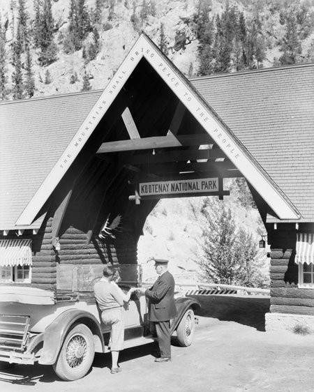
Kootenay
British Columbia's only Rocky Mountains park, sitting on the provincial border with Alberta (and Banff National Park). A narrow 1,406 km² stretch of land that runs parallel with Alberta Highway 93 and part of the Kootenay River, it offers a convenient, scenic drive. The mountainous landscape features enormous canyons and valleys as well as large glaciers and hot springs, many of which have been adapted for public use.
Pacific Rim National Park, British Columbia.
Regien Paassen/Shutterstock
Kouchibouguac
239 km² portion of New Brunswick's northern coast, defined by the long, thin Barrier Islands that literally barricade its fjords and inlets from the Northumberland Strait. Diverse forested landscape offers opportunities for a lot of activities including mountain biking, swimming, paddling, camping, hiking, and (in the winter) cross-country skiing.
La Mauricie
A 536 km² heavily forested valley in the south interior of Quebec. Numerous large lakes are surrounded by popular camping and picnicking sites. Known for its waterfalls and scenic trails.
Mingan Archipelago
Hundreds of small islands off the Quebec coast of the Gulf of St. Lawerence totaling 151 km² of territory in all. Many islands have rocky beaches and massive stone monoliths. Six islands offer campgrounds, but the region is most popular for kayaking, canoeing, motor boating, and scuba diving.
Mt. Revelstoke
262 km² territory in eastern British Columbia in the Rocky Mountains region. As the name suggests, the park is dominated by Mt. Revelstoke, as well as the enormous Clachnacudainn Icefield. The most famous attractions are the Winding Meadows in the Sky parkway, a scenic drive to the mountain top, and a small ski resort. Numerous low trails through the surrounding forest at the mountain base are known for their wildflowers.
Nááts'ihch'oh and Nahanni
Two parks in the interior Northwest Territories, comprising a total territory of 34,850 km² in all. Parks are continuous, but remain legally separated for treaty reasons and often counted as one. An untouched, remote wilderness with no manmade facilities, the terrain is rocky and mountainous and home to a famously intimidating formation known as the "Cirque of the Unclimbables." The massive Nahanni River runs through the parks, making it a popular destination for ambitious kayakers. Must be visited by plane.
Pacific Rim
Two thin coastal regions — Long Beach and the West Coast Trail – on south eastern Vancouver Island with the Broken Group Islands archipelago in between, totaling 510 km² of territory in all. The beaches are substantially developed and a major tourist destination known for offering some of the Pacific northwest's best hiking and surfing.
Point Pelee
The small, 15 km² tip of the Point Pelee Peninsula, which reaches into lake Erie from southern Ontario. The park is mostly marshland with multiple lakes, rocky coasts, and some desert-like savannah areas. Easy to visit, it is a popular destination for camping and hiking.
Prince Albert
Rectangular 3,875 km² parcel of land in central Saskatchewan specifically designed to serve as an ideal spot for a wide variety of outdoor activities. The scenic forested terrain, numerous large lakes, beaches, and rivers, provide opportunities for hiking, camping, and boating. The park is also home to a large golf course.
Prince Edward Island
Three thin, non-contiguous pieces of the northern coast of Prince Edward Island totaling 27 km² in all. It's best known for containing one of the preserved home of Anne of Green Gables author Lucy Maud Montgomery (1874-1942), as well as the landscape that inspired some of the locations in her iconic book.
Pukaskwa
1,878 km² portion of land on the coast of Lake Superior in south central Ontario. Famous for the Coastal Hiking Trail that runs along nearly half of the park's coastline.
Jasper National Park, Alberta.
BGSmith/Shutterstock
Qausuittuq
11,008 km² of territroy on Nunavut's Bathurst Island. Consists of rocky bluffs, vast, dry tundras, and ice-filled waters, occupied by caribou, muskox, and polar bears. Has no manmade facilities of any sort and is very difficult to visit, though tourist ships sometimes make brief stopovers.
Quttinirpaaq
Vast 37,775 km² stretch of territory on the northernmost point of Nunavut's Ellesmere Island, making it the most northernmost national park in the world. A mostly frozen terrain of mountains, glaciers, and iceberg-filled waters. Though the park is mostly untouched wilderness, the importance of Canada's northernmost point for scientists and the military has seen some the development of some permanent infrastructure, and the park is often used as a base site for those heading to the North Pole. Skiing, hiking, and even camping is possible.
Riding Mountain
An elevated 2,968 km² territory in central Manitoba, encircled by developed farmland and residential areas. Its location has made it a popular vacation destination, with the large Clear Lake, in the park's south being a well-liked spot for camping, boating, and swimming. It is Canada's second-most urbanized national park, with some of the homes and shops of the surrounding city of Wasagaming, as well as several hotels, located inside its borders.
Rouge
A very unusual national park consisting of a 79.1 km² of strip of contiguous parkland running through the Ontario cities of Toronto, Pickering, Markham, and Uxbridge. Dubbed the world's first "urban national park" it consists of wetlands, rivers, and orchards, and a small beach at the park's narrow endpoint, where it touches the coastline of Lake Ontario. Outside the green areas, it contains plenty of standard suburban amenities, like shops and restaurants, as well as the Toronto Zoo.
Sable Island
A thin, 30 km² island in the Atlantic, far off the coast of Nova Scotia. Known mainly for its population of wild horses and remnants of shipwrecks, it is under strong control by the Canadian government. No camping of any sort is permitted, and short government-guided tours is the only real interaction that's allowed.
Sirmilik
Northern portions of Nunavut's Baffin Island, consisting of three non-contiguous areas of land separated by the Navy Board Inlet and the Eclipse Sound, totalling 22,000 km² in all. The most popular of Canada's far northern parks, it receives regular airplane service and cruise ships in the summer. The mountainous terrain is accessible for hiking, skiing, mountain climbing, and camping, while the inlets can be used for kayaking and scuba diving. Sight-seeing attractions abound, including remnants of Inuit villages, enormous icebergs, and exotic northern animals like walruses and narwhals.
Terra Nova
399 km² territory on the northern coast of Newfoundland. A popular and easily accessible park, its mix of forest, beaches, and lakes offer ample opportunity for a wide variety of outdoor activities, as well as many indoor amenities like museums, hotels, and restaurants.
Thousand Islands
An exaggerated name, the park actually consists of something closer to 200 small islands in the St. Lawrence River, off the coast of southern Ontario, comprising 24 km². The main attraction is kayaking between the islands for camping or hikes. Located on the U.S. border, the islands played an important role during the American Revolution and War of 1812, and there are some historic sites.
Torngat Mountains
9,700 km² tip of northern, coastal Labrador, dominated by the Torngat range, which consists of Canada's highest peaks east of the Rockies, and a craggy coast. The environment is arctic-like and is popular for backcountry skiing and mountain climbing, as well as boat cruises in its fjords. A significant location of Inuit archeological sites.
Tuktut Nogait
Northeastern corner of the Northwest Territories with a tiny coastal area via the Outwash River. Can only be accessed by plane. The craggy, rocky, mountainous landscape of cliffs and caverns is intersected with many rivers popular with kayakers. A wealth of Inuit archeological sites.
Gros Morne National Park, Newfoundland.
Wildnerdpix/Shutterstock
Ukkusiksalik
20,880 km² region of eastern Nunavut surrounding Wager Bay. The rocky coast and bay area is rich with exotic arctic plants and animals, as well a vast array of Inuit archeological sites and remnants of the European fur trade. The cultural importance of the park means the Government of Canada tightly controls and monitors all visitors.
Vuntut
4,345 km² northern tip of Yukon just to the south of Ivvavik National Park. Dominated by wetlands surrounding many small lakes, and home to vast herds of Caribou. An untouched wilderness preserve with no manmade facilities, it is very difficult to visit, even by plane, and receives very few visitors.
Wapusk
11,475 km² portion of northern Manitoba on the coast of Hudson Bay. Consists of flat wetlands in the winter that become vast fields of frozen tundra in the summer, and is the famous home of a large population of polar bears. Visiting is complicated though there is a thriving tourism industry of polar bear-watching on all-terrain trucks.
Waterton Lakes
505 km² area in southern Alberta located on the U.S. border, contiguous with Glacier National Park in the United States. One of the Rocky Mountains parks, Waterton is known for its scenic hiking trails, waterfalls, canyons, and three large lakes, as well as the Prince of Wales Hotel, one of Canada's most famous pieces of Victorian architecture. Like the other Rocky Mountains parks, it is heavily developed and features numerous shops and restaurants.
Wood Buffalo
Canada's largest national park, comprising a 44,972 km² portion of northern Alberta and part of the Northwest Territories — the only Canadian national park to cross a provincial border. Given its size, the mostly flat, forested park contains a vast array of natural attractions, including the impressively-sized Lake Claire and Buffalo Lake, the large Peace River, and sprawling salt plains. The area was once the capital region of the Hudson's Bay Company, and there are historical sites commemorating its rule.
Yoho
1,313 km² Rocky Mountains park on the British Columbia side of the mountainous Alberta border. In addition to its mountains and backcountry skiing, it's known for its lakes and rivers, particularly the Kicking Horse River, which is popular for rafting, and the Burgess Shale fossil beds. Like the other Rocky Mountains parks, it has many modern shops and restaurants.
More About Canada's National Parks